Early Days at Eraring
Lake Macquarie
Percy Simpson
Lieutenant Percy Simpson received two grants of land, each of 2000 acres which he chose adjacent to one another in the vicinity of Dora Creek however the grants were not surveyed for two or three years. He was granted convict servants to clear the land which was named Kourumbung. A house and stockyards were constructed and he owned an extensive herd of cattle. His grants extended from the southern bank of Dora Creek, westward from the confluence of Dora and Stockton Creeks to the vicinity of Cooranbong as it is today, and southward to Mandalong and Wyee.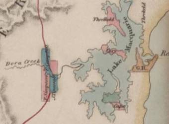
In a mistake by surveyor-general John Oxley, and unbeknown to Percy Simpson at the time, one of his 2000 acre grants was cancelled.
Later this grant was selected by John Tingcombe [17]. Patrick Frederick Campbell also acquired land in the district.
In lieu of the grant that had been cancelled Percy Simpson selected a further 2000 acres near the mouth of Dora Creek. There was a lengthy wait while paperwork was approved however he was officially granted title to two thousand acres of land known as E-ra-ring on 7th April 1838.......
Commencing at the South extreme of the Western boundary line at Dory Creek and Bounded on the West by a North line of one hundred and thirty seven chains and fifty links; on the North by an East line of one hundred and seventy six chains to a salt water Creek, and by that Creek to the Waters of Lake Macquarie; on the East by the Waters of Lake Macquarie southerly to the mouth of Dory Creek; and on the South by Dory Creek upwards to the South extreme of the Western boundary line. [1]
John Edye Manning
With financial difficulties and a large family to support, Percy Simpson sold his 2,000 acres E-ra-ring later in 1838 to John Edye Manning [16]. Simpson had been dissatisfied with the land, considering it barren scrub lacking adequate water.Frederick A. Hely
In the early 1830's Frederick Hely, Superintendent of Convicts in Sydney was leasing land at the mouth of Dora Creek - part of the E-ra-ring land. Hely became ill in January 1836 and resigned from his position. He died in September that year and his wife Georgina and Edward Hely continued to lease the land after his death [2]. Edward Hely apparently afterwards acquired the Er-a-ring land from John Edye Manning.Alfred Holden
Alfred Holden was appointed Police Magistrate at Brisbane Water in 1837.[3]In a series of complicated land deals between Edward Hely, Alfred Holden and George K Holden the second Percy Simpson grant changed hands.....
Land Sale Edward Hely (vendor) to Alfred Holden (purchaser)......All those eight hundred and ten acres of land situated in the Co. Northumberland being part of two thousand acres lately granted to Percy Simpson and by him sold to John Edye Manning; which said land thereby is bounded in irregular lines on the Southern and South Eastern sides by the waters of Lake Macquarie, on the North commencing at the Extreme North Western corner of the said two thousand acres by ninety eight chains of the Northern boundary line thereof; and on the South West and North East by parallel lines running in a South Eastern direction to the waters of Lake Macquarie from the extreme point of the said ninety eight chains and dividing the land appointed on the North East from the two thousand acres belonging to Edward Hely [16].Another six hundred and ten acres was similarly sold.
In December 1839 the two thousand acre grant seems to have belonged jointly to Edward Hely, G.K. Holden and Alfred Holden. Alfred Holden's portion was known as Bourke's Estate.
In February 1840 Alfred Holden and George K Holden sold their portions to Edward Hely for £800. The land was subdivided into town allotments and marketed as Newport.
Auctioneer Mr. Smart advertised portions of land for sale at Newport in July 1840. [4] It was said to be part of Holden's Bourke Estate
Sale of Land at Newport
Newport
Mr. Smart will sell by auction at his rooms in George street Sydney on Thursday 30th July at Twelve o'clock
A few Allotments of the above Township
The Township of Newport, forming part of the Bourke Estate, will be found, on reference to the map, the midway station between the Brisbane Water and the Maitland or Newcastle districts having the Hawkesbury and the Wollombi Ranges in the west and the extensive and picturesque Lake Macquarie with its fertile banks and the sea on the east.
Among the many natural advantages of its position for which it was selected as a grant by one of the early commandants, who was also an eminent surveyor or engineer, the following may be enumerated -
Newport is contiguous to that part of the coast known as Reid's Mistake or Lake Macquarie and the resort of fishing boats from Sydney and Newcastle, the entrance at certain seasons of the year admitting also vessels of larger tonnage. The borders of this lake are famed for the inexhaustible source of investigation which the numerous specimens of minerals and the continuation of the coal strata from Newcastle have so repeatedly presented to the geologist and the lover of science.
Newport has in its vicinity forests of the best Colonial timber especially cedar of the finest quality quantities of which have been for years cut in the district and the trade is at this time carried on it its full vigor.
The selection of Newport as a township has been greatly approved of by Colonists of experience as well a engineers and surveyors, while by several of the first families of the Hunters River districts it is looked forward to with some degree of expectation as the only means of relieving them from the serious inconvenience of a long and perilous night voyage by steam, during the more tempestuous seasons of the year. Added to its mid way position between the above important districts the road is with a few immaterial exceptions not only direct but level. The distance of the Township is computed by the government and private surveyors to be only about 25 miles from Maitland or Newcastle and East Gosford, the township of Brisbane Water, from which place the steamer at present running makes the trip to Sydney in three or four hours; by means of which communication it is evident not only residents on the Hunter but their flocks and herds will be enabled to travel with ease certainly and dispatch so that sales will be effected without subjecting stockholders to the dearth and high cost of agistment, or grazing round Sydney and the more serious losses of delays of the present circuitous routes from those districts to the metropolis.
The scenery of the lakes which front Newport is considered by travellers who have visited them to resemble some of the most beautiful on the Continent of Europe and requiring only the industry of man to perfect such resemblance, The soil of the township and the adjacent lands will vie in comparison with any that can be selected from the most alluvial parts of the Colony and favored as this spot is with coast rains at all seasons as well a s abundant natural supplies of water, Newport will assuredly be found a place of comfort and repose for the traveller to and from the Hunter - a delightful and healthy retreat for the invalid and to the capitalist of every description as well as the emigrant of industry and enterprise a township adapted by nature and especially its relative position between Sydney and the Hunter for the immediate and unlimited employment of capital talent and energy.'[4]
The first allotments were sold soon afterwards. Perhaps the stands of timber mentioned in the above advertisement encouraged and sustained the settlement for a while. However the claim of excellent alluvial land was later proved incorrect when rust ruined wheat crops [5]
Bushrangers
The district was in uproar in 1840 when raided by the Jewboy Gang bushrangers. These marauders were enthusiastically pursued to the Watagans by Magistrate Alfred Holden who took with him on the pursuit ticket of leave holders and constables. The gang together with their new recruit from the district, Richard Glanville, managed to evade capture.[6]Cattle Thieves
Cattle thieves were also said to be active in the Lake Macquarie district. Jeremiah Diplock who arrived on the Coromandel in 1820 after being sentenced in Sussex to 7 years transportation, John Kindrick, known as 'Hellfire Jack' and William Bramble who lived in the vicinity were known to the authorities.[5]Beauty of the Lake
However proponents for the development of the area were not to be deterred from their enthusiasm and in February 1841 The Australian reported-It is a great advantage to the inhabitants of these districts, that the new road from Maitland to Gosford, discovered by Mr. W.H. Wells, proves so excellent a one. It avoids the hilly range of Wyee, and the Sugar Loaf mountain, and is also shorter than the road lately in use. It is, our readers will observe, upon this new road that the town of Newport is situated, having Lake Macquarie on the one side and the road on the other. A bridge has been constructed, nearly a furlong in length, across a small arm of the lake; by crossing which, and also by means of a punt at Dora Creek, a saving of eight miles will be effected.
The public will further hear with interest, that the entrance from the sea to Lake Macquarie, an entrance which is commonly called 'Reid's Mistake,' is discovered to be navigable. An inlet for shipping is thus given into a most safe and beautiful harbour, 300 miles in circumference; the only located spot of which, at present, is the aforesaid town of Newport. It seems obvious that the settlers on Jerry's Plains will, instead of going out of their way to Newcastle or Maitland, bring down their wool to Newport direct, as shipping can lie within a cable's length of the shore. The Kangaroo will shortly be engaged to perform a trip from Sydney to Newport, passing through the Strait called 'Reid's Mistake' and affording the passengers a view, almost for the first time since the existence of the colony, of Lake Macquarie in its entire beauty. We shall hope to learn that these new projects, having in their end so important a benefit, are prospering in a manner which they so well deserve.
Inn at Newport
By 1841 an inn was operating at Newport. Innkeeper William Thomas Mitchell was married to Mrs. Jane Sherlock on the 10th August that year by visiting Minister the Rev. Edward Rogers. [7] It seems Mrs. Sherlock's husband, a shingle splitter, had been drowned on the lake the previous June when out on a pleasure cruise with three others. He was at the time building the hotel together with Mr. Mitchell.Perhaps it was this inn that a Mr. Ainsworth was selling liquor from later [5]. This inn was closed down when Ainsworth was found guilty of selling liquor without waiting for his license to be approved. The Police Magistrate at Brisbane Water seized all the liquors he had in stock effectively closing him down. There was said to be a need for an Inn for travellers apparently often passed that way on the way between Maitland and Brisbane Water.
School
In October 1841 the Monitor reported that a school house was about to be built at Newport. The funds were being raised by subscription with the government to contribute towards its support an equal sum.Lake Potential
In July 1841 the Australian once again reported on the potential of Lake MacquarieWe are informed that a vessel has at length arrived from Lake Macquarie with coals. This is an occurrence of some interest, as it establishes the fact of the entrance to the Lake (commonly called Reid's Mistake) being navigable. The Ann, of Newport (the vessel in which the coals arrived), is one of twenty tons burden, but it is said that vessels of much greater size can effect an entrance. If such be the case, it really is a most important circumstance. Lake Macquarie is of no mean extent. It might, indeed, from its dimensions, be almost, with propriety, be termed a sea; whilst, not the extreme beauty of its scenery merely, but the remarkable fertility of the land on its banks, entitles it to the attention of every new settler. Were small farms laid out on its margin, being, as it is, upwards of three hundred miles in circumference, we are certain they would be bought up with avidity, and to the great advantage of the Colonial exchequer. Every one knows at what a high rate small patches of land sell, having frontage to the Hawkesbury, and that solely on account of their possessing the advantage of water carriage to Sydney. Nor is the fertility of its banks the only recommendation of this fine Lake. Shingle wood, in many parts, abounds; whilst, at the head of Dora Creek (the southern boundary of the Newport property)' timber of the more valuable kinds, but particularly cedar, is to be met with in abundance. Aware of the richness of the land on this fine creek, which is about five hundred feet wide, Government has lately withdrawn from sale a section on its south bank, to some parties well known, by the name of Stingaree Point; but the extensive estates in the immediate neighbourhood - those of Mrs. Hely, Mr. Campbell, and John Terry Hughes, Esq. - have all of them more than an average proportion of good soil. Much good land, too, is not yet taken up. It is a pity these estates are not apportioned to small and industrious settlers, who would make them far more availably useful than they at present are, as mere fields for grazing. We trust the adjacent Crown Lands will be put up in small portions, within the means of the little industrious settler to purchase, and we are much mistaken if the result be not of the most flattering description.'
In 1842 the Sydney Herald reported favourably once again noting that the area was at length beginning to develop its true resources although slowly owing to poor financial times.
They noted that a fair trade had sprung up in the shingle business.
The entrance of the lake is still believed to be un - navigable, notwithstanding shingles being are being sent from the place, both to Newcastle and Sydney. Time however must eventually remove this prejudice, and as shingle wood (which is getting so scarce in other quarters) is to be had on the Lake without carting, (in almost any quantity), a considerable trade may be expected to arise eventually. One or two active, stirring folk, would do well in this line. They might get their shingles into Sydney market several shillings a thousand cheaper than they can be had elsewhere, where the ground is more beaten. Beautiful little farms are springing up on the banks of the Lake, and the small settlers seem, on the whole, pleased with their prospects. There would be plenty to do here for a steamer, to run between Newport and the entrance. There is a sailing vessel for the purpose, but a small steamer would answer better. It is said, the East Gosford Packet is to be put on for this place, to run regularly between it and Sydney. She would do well enough certainly, but several such will be wanted before long. Nothing can exceed the great beauty of the scenery in this neighbourhood, and should bathing-houses be erected, in connexion with a good inn, it would be a delightful resort for the good folk of Maitland, and that neighbourhood.[8]
Despite these glowing reports this fledgling township on the edge of the lake, like George Weller's proposed township 'Hampton' on the banks of Cockle Creek, was doomed to failure. A line of road connecting Sydney with the Hunter Valley favoured by Percy Simpson failed to eventuate and settlers from the upper Valley did not use Newport to ship their wool. With the entire colony suffering under the circumstances of the depression of the 1840's, the Newport settlement failed entirely. Settlers in the district were not immune to the effects of the depression and by 1845 Alfred Holden was undergoing insolvency proceedings.
Quiet Backwater
With the gradual decrease of population along the north shore of Lake Eraring, and the build up of population along the shore of Dora Creek, the name Newport was applied to what is now the township of Dora Creek.A few settlers remained in the district making their living by cattle, agriculture or fishing - farmer John Minton, Henry Worley, constable and sheep farmer and Edward James also a sheep farmer. [9] James Bradford ran cattle at Newport in 1846. Settlers travelled by water, horse and dray. Market gardens were planted and orchards established but the area remained mostly undeveloped.
By 1880 the area of Lake Macquarie was described as
one of the most wild, romantic, and picturesque spots that can be imagined. The route to the Lake is full of interest abounding with wild flowers, scented groves of myrtle, valleys of lilies romantic spots and curiously formed trees; altogether affording amusement to those in search of real recreation.'[10]
In 1885 the Excelsior Land Company purchased a number of estates near Dora Creek and subdivided them for housing. One of these estates was situated at Eraring. It was a portion of the original grant to Lieutenant Percy Simpson half a century earlier and part of the estate which was subdivided for the town of Newport in 1840 [5]
Railway Station at Dora Creek
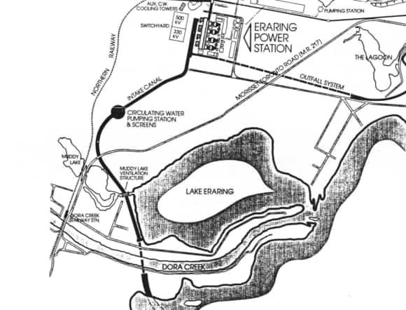
With the opening of the railway station at Dora Creek in 1889 access to the area became easier and goods could be taken to market. Those then and for many years living in Eraring walked from the railway station across Muddy Lake to their homes.Image: Map - Location of Muddy Lake

Image: Dora Creek Railway Bridge
Land Sale at Eraring
In 1910 the Excelsior Land Co. sold farming blocks at Eraring. D.P.6747, which showed a subdivision of part of Portion 86, was declared 28 March 1912. Streets formed included Foreshore, Macleay, Border, Cross and North Streets, and Point Piper and Rocky Point Roads.History of Eraring, Lake Macquarie and District Historical SocietyThe Excelsior Land Co provided a further subdivision at Eraring in 1910 and small blocks were able to be purchased. The first block sold was to Mr. F. Hely.
James Simpson, a school teacher at Yarramalong who purchased a waterfront block at this time was no relation to Percy Simpson who had the original grant. Simpson's beach may have been named for him. His daughter Gertrude Roberts contributed much to the community including being the first sewing teacher, Secretary of the Women Eraring Auxilliary League, Secretary of the Eraring War Auxiliary, Hon. Secretary and Life Member of Eraring P & C Association and Postmistress. [19]
Waterfront land at 21 Payten-street was purchased by the Lambert family around this time.
Dr. Leighton-Jones
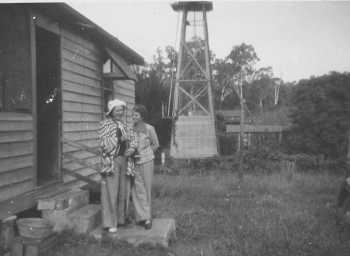
Later the property across the creek from the Lambert purchase became the residence of Dr. Leighton Jones who was renown for his work with monkeys. Images: Top Joyce and Annie Hyde at Eraring. The monkey cages can be seen centre of photo. Below Monkey Cage 1939
Post Office
On 1st April 1924, Mrs. Lillie F. Johnson of Chelmford Ave., Eraring Lake, wrote to the Deputy Postmaster-General seeking the establishment of a Receiving Post Office for the Eraring Estate. She offered to undertake all duties in connection with conducting the office. The Lands Department raised no objection to establishing a Post Office at Eraring, described at the time as a 2000 acres property between the Great Northern Railway on one side, Lake Eraring, and on another side running to Rocky Point Road. A Receiving Office was opened on 1st April 1925 in the charge of Thomas Johnson who became Receiving Office Keeper and Mail Porter. Mrs. Lillie Frances Johnson was Assistant. The office was situated on the main road about 100 yards from the Public School near Macleay Street. Annie May Johnson, his daughter was appointed Telephone and Receiving Office Assistant. In May 1927 Esther Jean (Essie) Johnson became the Assistant. It operated as a Receiving Office until its status was raised to a non-official post office, on 1 January 1927. Mr. Johnson continued until 1st September 1939 when John Crawford Johnson took over as non-official Postmaster.Mrs. Gertrude Roberts took over in the late 1940s and the building was moved years later to the site in Payten-street where it remained for many years [19]. The office closed 30 November 1973.
The post office building was relocated to the grounds of the Eraring Public school in 1993. [20]
School
Application was made for the establishment of a school at Lake Eraring in 1922 and the names of fifteen probable pupils living within a mile of the proposed site were submitted. The application was granted on 23rd October 1922 and negotiations were commenced for the acquisition of a suitable site. Lot 17 of the Eraring Estate was decided upon and this land comprising 6 acres, 1 rood, 12 perches was purchased from the Excelsior Land Investment and Building Company Ltd. at a cost of £50. A classroom to accommodate 30 pupils was completed with a hat-room attached. The building was constructed of wood with a galvanised iron roof. Plans and specifications were prepared by the Government architect and work carried on by Mr. A. Partridge-Wall at a cost of £397. 10s 8d. [19]Mr. Bruntnell, Minister for Education, officially opened the new school at Eraring in 1924. A large gathering of residents and guests, in all about 200 persons, were present. Mr. Bruntnell, accompanied by his secretary, were met at Dora Creek (Railway Station) by Mr. W. H. Varlow, president of the Eraring Parents and Citizens' Association, and conveyed by car a distance of three miles to the school, where the Minister was presented with a button-hole, and welcomed by Miss Marjorie Varlow. Mr. Bruntnell said he was pleased to accept the token, and the welcome so beautifully expressed. Luncheon was then served by the ladies, and 85 adults were seated at the tables, under bough shelter. The Minister thanked the ladies for the excellent lunch, and said he did not know when he had enjoyed a meal so well.
The Minister expressed regret that he could not make his stay longer. Three ringing cheers were given as the car conveying him left the school grounds to catch the train for Sydney. Weather conditions were ideal, and an excellent programme of sports for children and adults were well carried out during the day on the school grounds. The President, Mr. Varlow, moved a vote of thanks to the ladies, which was seconded by Mr. Adam Shepherd. The children were supplied with meals on the ground. [21]
In October at the annual meeting of Eraring parents and Citizens Association, Mr. W. H. Varlow was elected President; Mr. J. Parkinson vice-president; Mr. A. J. Pope secretary. Treasurer Mr. W. Jayne. During the year the association had erected a fence around the school, the department supplying the wire and gate. The department had also added a verandah to the building. [22]
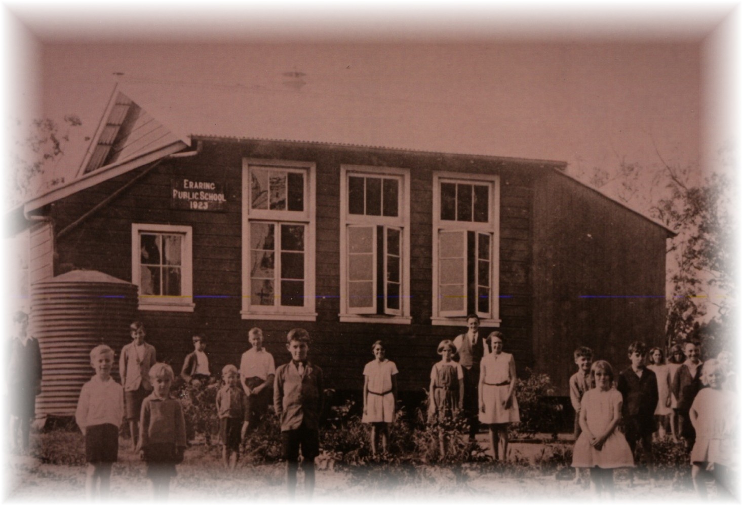
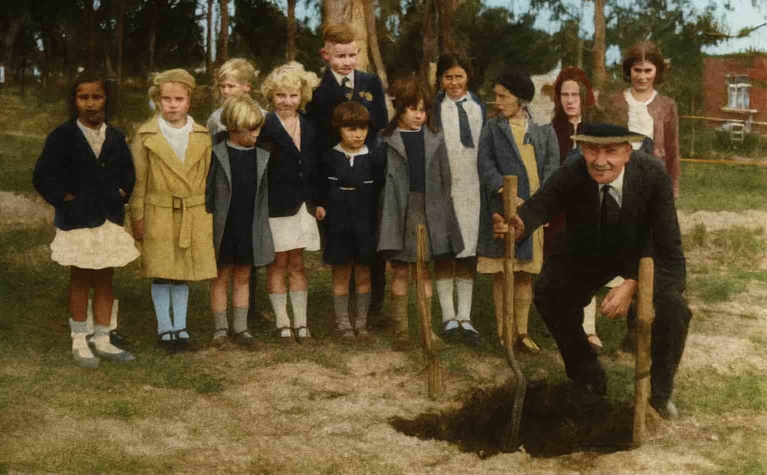
Image: Participants in the schoolground beautification work which was the centre of interest in the Arbor Day celebration at Eraring, Lake Macquarie - [23]
Eraring School of Arts
The Eraring School of Arts was constructed in 1928 on land generously donated by Mr. Parkinson. The first Trustees were Mr. W. Jayne, Mr. Mobs, Mr. Pope and Mr. Wilcock. The hall quickly became the centre of local social activity, with dances held there every Saturday night. Admission was 2 shillings, and in a long-held Australian tradition, the ladies would bring a plate while tea and coffee were provided. The building featured a large dance hall and two spacious rooms at the rear—one used as the kitchen and the other serving as a cloakroom and library. As with community halls throughout the district in this era, the hall played a significant role in the social life of the town, with picnics, fetes and community events organised to raise the funds needed for its construction.The State Electricity Commission purchased the land and quite a lot of other land and homes, being for the power station and its buffer zone. The School of Arts regrettably deteriorated and was knocked down. In 1980 the School of Arts was no longer there.[20]
Residents at Eraring 1934 and 1946 extracted from Electoral Rolls available at Ancestry.com. Australia
Campbell, Clarice May, home duties
Christiansen, Elizabeth, home duties
Christiansen, Thomas Christian, farmer
Conley, Mavis Annie, home duties
Conley, Thomas Cyril, farmer
Edwards, Alfred John, Lake Eraring, labourer
Edwards, Eliza Jane, Lake Eraring, home duties
Jackson, Margaret Elizabet, Home Duties
Jayne, Annie May, home duties
Jayne, Percy Arnold Edward, orchardist
Johnson, Esther Jean, home duties
Kelso, Hugh, Biddulph-street, carpenter
Kelso, Rebecca Ruth, Biddulph-street, home duties
Kennedy, Patrick John, farmer
Lyons, Joseph Marcus, school teacher
Lyons, Mary Kermeen, home duties
Parkes, Jessie, home duties
Parkes, John Kenneth, master mariner
Ralston, Edward Bolton, farmer
Ralston, Gertrude Julia, home duties
Shaw, Thomas, motor driver
Shaw, Violet, home duties
Simpson, Edward George, Border street, farmer
Simpson,Sarah Ellen, Border street, home duties
Taylor, Annie, home duties
Taylor, Cletus, carpenter
1946
Bohm, Frederick William Leigh, Ivydale, labourer
Bohm, Ivy Ethel, Ivydale, home duties
Burns, Constance Rose, Lake Eraring via Dora Creek, home duties
Buttsworth, Herbert Eric, farmer
Christensen, Elizabeth, home duties
Davidson, Ralph John, Lake Eraring, no occupation
Dobb, Cyrus Benjamin, Border-street, fitter
Dobb, Mary Ann Clews, home duties
Dunn, Gladys Alice, home duties
Dunn, Henry William, farmer
Edwards, Walter Albert, carrier
Einsaar, Gustav, Rocky Point Road. No occupation
Gourley, Robert, Border-road, labourer
Gourley, Stella Lillian, Border-road, home duties
James, Bridget Ccelia, Lake Eraring, home duties
James, John Valentine, Lake Eraring, poultry farmer
Jayne Selina,
Jayne William Arthur, retired
Jennings, Lillian Elizabeth, home duties
Johnson, Lillian Ernestine May, home duties
Kay, Elsie Isobel, The Shack, Awaba road, Lake Eraring, home duties
Kelso, Hugh, Biddulph-street, no occupation
Kelso, Rebecca Ruth, Biddulph-street, home duties
Lyons, Joseph Marcus, school teacher
Lyons, Mary Catherine, Payten-street, home duties
McKenzie, Margaret, home duties
Martin, Arthur Tasman, Lake Eraring, farmer
Martin, Daisy Constance, Lake Eraring, home duties
Mielen, Arvid August George, farmer
Mielen, Elizabeth, home duties
Mobbs, Lois Corleen, Payten-street, picture fitter
Patrick, Mary Frances, Payten-street, home duties
Ralston, Edward Bolten, farmer
Ralston, Gertrude Julia Icilina, home duties
Roberts, George Henry, Lake Eraring, orchardist
Roberts, Gertrude Doris, home duties
Sawert, Beryl May, Payton road, Lake Eraring
Taylor, Leslie Edward, carpenter
Taylor, Ruby, home duties
Taylor Vincent, retired
Turner,Amy Rebecca, home duties
Whitehead, Phillip, Eraring Estate, farmer
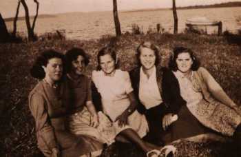
Image Centre: Kitty Lambert. Far Right: Iris Lambert at Eraring foreshore c. 1940
Notes and Links
Opening of Eraring Public School 1924
Monkeys at the Lake - Newcastle Morning Herald 3 January 1939
Arbour Day Celebrations at Eraring 1936
New Swimming Baths at Eraring 1939
Colonial Events 1800 Lake Macquarie History
Hunter River 1797
Discovery of Lake Macquarie
Settler and Immigrant Ships
Hunter Valley Place Names
How to Use the Map
To enlarge map click on the top right corner
To use the search function 🔎 enlarge the map and use the menu top left to access map legend
Browse entries on left of page
On computers scroll to zoom in and out
On mobile devices pinch to zoom in and out
*Note - Links do not work on mobile devices
Sources
[1] State Records Authority of New South Wales; Registers of Land Grants and Leases; Series: NRS 13836; Item: 7/460; Reel: 2549 Description Year Range: 1836-1840 (Vol 9) Source Information Ancestry.com. New South Wales, Australia, Registers of Land Grants and Leases, 1792 - 1867[2] Sydney Gazette 15 September 1836
[3] Returns of the Colony - Colonial Secretary 1837
[4] The Australian 23 July 1840
[5] Clouten, Keith H. Reid's Mistake, p. 113 - 116
[6] Roope, C., Gregson, P., An Organised Banditti, The Story behind the 'Jewboy' Bushranger Gang, Colin Roope and Patricia Gregson, Lake Macquarie,2002.
[7] Sydney Morning Herald 24 August1841
[8] Maitland Mercury 13 December 1845
[9] 1841 Census
[10] Shaw, W.H, The Newcastle Directory 1880/1881
[11] The Australian 4 February 1841
[12] The Australian 13 May 1841
[13] The Monitor 27 October 1841
[14] The Sydney Herald 28 October 1841
[15] The Sydney Herald 27 January 1842
[16] State Records Authority of New South Wales; Kingswood, NSW, Australia; Archive Reel: 1587; Series: 12992; Description: Registers of Memorials for Land. 1825-1842. Description Date Range: 1821-1838 Source Information Ancestry.com. New South Wales, Australia, Land Grants, 1788-1963
[17] Clouten, Keith H. Reid's Mistake, p. 42-48
[18] Map showing Percy Simpson's grant at Cooranbong
[19] Sixtieth Anniversary Committee, Eraring Public School History, The First Sixty Years, 1984
[20] History of Eraring, Lake Macquarie and District Historical Society
[21] Newcastle Morning Herald 9 February 1924
[22] Newcastle Morning Herald 31 October 1924
[23] Newcastle Morning Herald 5 August 1936
↑